
Welcome to road work site of Tokyo Metropolitan Expressway !
I introduce you a brief description of the road work.
 This is a basic road unit implemented with the debug code. Five points of orange color at the right edge of the road unit show a basic position. Center point shows present position, and surrounding four points show 0.1 degree moved positions to north-south, and east-west respectively. And just left of it, many points of green and red show the number of the road. The number of points shows numerical number on each digit (zero is shown by ten points.), and red color shows decimal digit. For example, the number of this road is "174.3". Please see the left edge of the road unit. There are four orange colored points followed by road edge parallel to the direction of the width of the road. This means that 1 degree moved in angle of the road to right or left. And there are 2 columns of 10 orange colored points in line for the direction of the length of the road. This means that extension to the direction of the length of the road, and distance of 1 point means 1 m. Therefore, if we extend this road more 10 m, then the left edge of the road unit reaches the most left orange points.
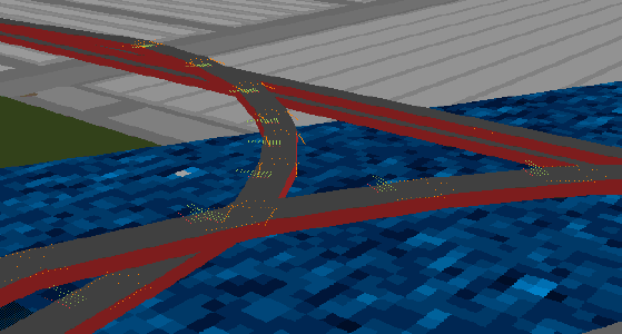 This is the scaffolding in use. It is the scene under construction of the Hamazakibashi JCT connecting "Belt highway of center of Tokyo" and "Haneda line", you can see it after version 0.4. (Now, I decide positions by calculating in part.)
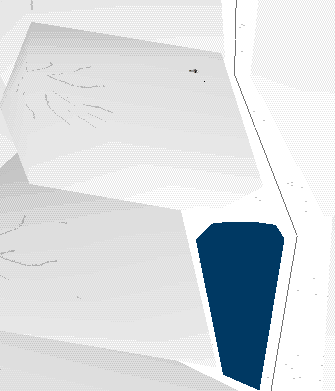
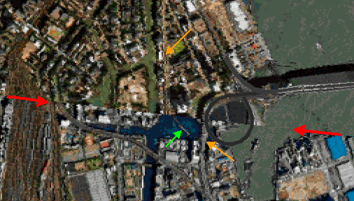 This is a texture at a west edge of Rainbow bridge. Two red arrows show a texture edge line. You can easily recognize that there is a difference of sea colors between upper and lower at the edge line, and coast line is completely not continuous. (Rainbow bridge itself is not affected from this texture edge, because it is a 3D object.) Two orange arrows show Tokyo MEX way Haneda line. You can see it, the road is divided to left and right completely. Green arrow shows a track of Tokyo monorail. In TwilightExpress scenery (they make Tokyo MEX way only the lights in the night), this monorail track is regarded as Tokyo MEX way, and divided roads are connected by force. This is good way for deceiving a person who doesn't know a track of Tokyo monorail, but it causes Tokyo MEX way little folded.
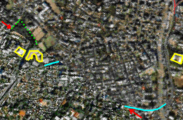
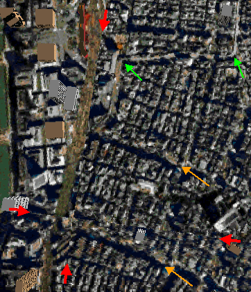 This is a texture at a south side of Tokyo station. Because four red arrows show texture edge lines, you can find there are four tiles of texture. Green place at the most left edge is an east edge of the Imperial Palace Plaza. Right of them there are buildings at Maruno-uchi area, and right of them there are brown lines which are tracks of Yamanote line, Keihin-Tohoku line, Tokaido line, and Tokaido-Shinkansen line. The red building near the upper edge is Tokyo station. It seems that they work hard to connect smoothly for tracks of railways, but there is a mess at Ginza area located at a right side. You can see that two orange arrows show completely the same place. A shape of the road toward to left from there is completely the same. The problem is green arrows. These arrows show Tokyo MEX way, left one shows Nishi-Ginza JCT and right one shows Kyobashi JCT. You can see that it is same latitude of Nishi-Ginza JCT and a south edge of Tokyo station. But in real, it is not. There junctions have around the same latitude to a north edge of Yurakucho station. By using a map, I find this position error is approximately 400 meters. It is not so clear from this photo, but you can recognize if you watch near areas, there is no Yurakucho station. It maybe disappear by locating at edges of tiles of textures.
 The next is Moto-azabu vicinity in Minato-ward. Red arrows are also edge line of textures. Sky blue lines are Tokyo MEX way #2 Meguro line, it is divided clearly. Green points shows Arisugawa park. You can find that the most of south part of Arisugawa park, Hiro-o station in subway Hibiya-line, German embassy, French embassy, and Shi-no-hashi area are disappeared. I feel no Arisugawa park is no good. Anyway, yellow places are Hiro-o hospital in the left, Keio kidergarten next, and Australlian embassy in the right. There are not lined in the same latitude in real as clear as the people who knows this area in detail.
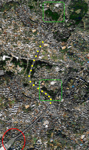 This is opposite, an example of object doubled. Here is the distance from Tokyo, vicinity of Tokyo toll gate of Tomei express way. Red circle is Tokyo toll gate. Green places are the same place. This is Tokakuin temple in Miyamae-ward in Kawasaki. Yellow dots show a road which is made forcibly by LAGO. There is tight curve even in a freeway. (But it's may be no problem even if it is true road, because Tomei express way is jammed all the time ??)
It is needed to connect roads for overcoming these position errors, at the road work of Tokyo MEX way. After all, it is still true that "Road work is a fine art." in the photo realistic scenery.

"Making of Yokohama scenery"
I start making Yokohama scenery with a new concept of the scenery called "illustrated scenery". Well, a motivation of making Yokohama scenery is derived from the Tokyo MEX scenery. Fortunatery, the construction of Tokyo MEX advances bit by bit, and it seems that the road work will go into Kanagawa-prefecture shortly. By the way, compareing MS version and TW version, it seems that TW version is better than MS version in a viewpoint of reality. Therefore, the construction of Tokyo MEX is done that TW version made first and convert it to MS version recently. This means that Tokyo MEX of TW version will go into Kanagawa prefecture at first. But seeing LAGO Tokyo scenery, the resolution at the place expressed only satellite photo without aerial photo is very low, and I hate putting the road to this kind of place expressed by the texture like a ghost house. Further, the width of the Tomei express way and Shinkansen line is very wide around 100 meter because of being traced forcely, and I hate put the road to this kind of place also.
And, I will start making... because there is no good points around this situation.... the aerial photo is not so low price comparing to satellite photos. The price of aerial photos is too high to pay only for the FS scenery by individual person except a case of exsisting a market of the scenery for charged and big quantity. Further, the problem of copyright of aerial photo will occur. If the copyright problem will none, it seems not so good to insist that "Scenery is a fine art." like Tokyo MEX road work, by only putting on the aerial photos. Anyway, if there is no money, the thing will done if there is a connection.......But I have neither of them......
So, after all, I have to start making all of them by myself automatically. I decide painting all paints based on the position of the map. Because I do not use a copyrighted matter like a "map" but use only a fact called "position", there is no copyright problem. On the contrary, it is no doubt that "Yokohama scenery is also a fine art !", because I paint paintings.
Therefore, the complete scenery should be made with no position error by painting based on a position of the map, but a fact is not so easy.
By the way, I think the policy of making Yokohama scenery. I think LAGO Tokyo scenery is a best product around Tokyo area scenery in a point of view having high quality and high rate of diffusion. So I would like to maintain a compatibility with LAGO Tokyo scenery on the premise. There is a problem. There are many position errors in LAGO Tokyo scenery. If the position errors exsist only in Tokyo 23 wards area, the scenery of Yokohama will have no relationship to this error. But I find that there are many errors around Atsugi base and Chofu airport too.
This is fairly a problem. Concretely, there is no error at the center of Yokohama, about 2 km error for north-east direction at Atsugi base and the size is enlarged about twice for north-south direction. At Chofu airport, there is about 3 km error for north-west direction. The method for fooling persons by cutting out or duplicating textures not for being striking done by LAGO Tokyo scenery is easiest. But if I will done this scamped work, the meaning for making Yokohama scenery is none, because the scenery is not suitable for "road work" by being lost consistency of the roads.
I MUST, with much quantity of work, I decide that I shift the position by distorting scenery blocks little by little to adapting Atsugi and Chofu of LAGO's scenery.
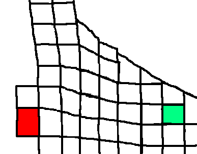 Please look this. This is a shifting condition. Green area is the center of Yokohama downtown with no position error. Red area is Atsugi base. There is position error for north-east direction and enlarged to north-south. The areas between these areas are shaped not exact square. The same procedure is done for Chofu, there is another distortion at the top of this figure to the left direction a little. This process needs very much work load, and can maintain consistency of the roads and tracks, and compatibility for LAGO Tokyo scenery.
By this precess, I clear the problem of position errors and compatibility. Next I think how much resolution is the best for this scenery. Too coarse causes no good looking and too fine causes too heavy. And too fine scenery is not able to be supported because of difficulty to get detailed information, e.g. the color of the roof of Mr.---'s house, the next door of Mr. ---'s house is not a house but a vacant land.....this kind of information has very high difficulty for getting it by only an individual person. But "the higher resolution than LAGO Tokyo scenery" is human nature to think so.
 After all, 1 pixel = about 6 m, is a resolution of this Yokohama scenery. This is a resolution more detail than the resolution of the center of Tokyo of LAGO Tokyo but not enough for seeing the information of each individual house. You can see a wider road at a residential area, a small local park, and a ground and a building of an elementary school. It is easy handling and interesting resolution, I think.
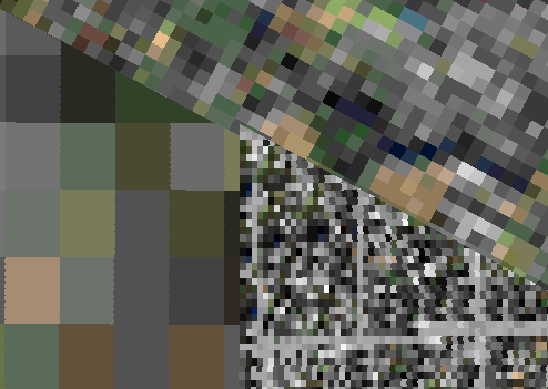
Please look at this figure. Upper side is a resolution of aerial photo area of LAGO Tokyo (over approx. 6400 ft.), left lower is a resolution of satellite photo area of LAGO Tokyo, and right lower is a resolution of my Yokohama scenery. By this figure, you will feel easily the resolution about 1 pixel = about 6 m. (A resolution of aerial photo area of LAGO Tokyo is 1 pixel = about 7 m under approx. 6400 ft.)

©1997-1998 S.Ito. All rights reserved.