Cashfiesta.com


Northern Territories map scenery

Japanese version

Historical background and problem

"position error problem"....This is a big problem had existed from an old days in FS. Like I experienced many times at Tokyo MEX scenery making, in spite of making with effort, if the reference ground scenery is changed, then I have to re-make whole of the scenery. It's really "a tower built on sand". In the case of a single object like a building, it is easy to move. In the case of long objects like railway or highway, I have to re-make almost whole objects because position; direction; length are affected almost completely damage.

There are some method to resolve this problem.
  1. Re-making MS default scenery itself.
  2. Making photo or illustrated scenery and regarding as the reference itself.
About #1, Mr. Murakami started Tokyo Bay Reconstruction Project in 1997. About #2, TwilightExpress released many versions of photo scenery series without position compatibility; from Tokyo scenery which was the first photo scenery of Tokyo vicinity area at FS98 era. About an illustrated scenery, I made Yokohama scenery in 1998, which is also aimed for connecting to the TwilightExpress Tokyo scenery.

There are following common problems.
  1. If the scenery is made with the intention for adjusting correct position in the map, it is almost unknown how correct the real position is.
  2. Because the covered area is restricted, the scenery is no use without the area, and there is anxiety whether it will be in the future or not.
  3. In the first place, there is no intention for adjusting correct position. (In TwilightExpress case...)
Therefore, let's make the scenery from the map itself for adjusting the reference position, we think.

** But, the situation becomes changing now. At this site, they announce that the high quality photo scenery in a vast area (e.g. Kanto district and so on) will be released in the near future. If this scenery will become the de facto standard, our this project will be unnecessary maybe...


Counterplan

Because something has been happened, it is late a little now, but I try to make a map scenery for a whole of Japan. Concretely, I use GSI's digital map 200000 (map image) Japan I/II/III as an original map for covering all Japan. Because this is a "map" scenery, the use of this scenery is different from usual one. That is; this is not for flight but for confirming a position. For example,
  1. Confirming a position of the river in the mountain area in SLEW mode.
  2. Enjoying the scene of like a 3D map in SLEW mode.
  3. Using this scenery as a position reference for making objects.
Specially #3 is for a person who makes a scenery. For example, if you want to put a village office object at XX village XX county XX state, you have no idea where to be putting it in previous. If this is a pin-point position, you can put it by corresponding Lat/Lon coordinate easily. But if you want whole road of the vicinity of the village, it is not easy to determining positions of all objects. You encounter position error problem if the area is vast.

And in the case of re-structing terrain of default scenery, you can use this scenery as a reference. In a present, Coast-Line-Maker or Ground2K are used for re-structing terrain, it seems that TGPeditor by PHOTEC (in Japanese) has many functions. (however, I try to use it and cannot succeed it by "I/O error".)

There are following defects in a map scenery.
  1. You cannot see the scene because this is a map itself.
  2. This is very heavy because it is equal to cover all of Japan by full resolution photo scenery, by making it as 4.8 m / pixel resolution.
  3. There are few position error, not completely zero.
About #2, it is better not to put all files at once, when whole Japan map scenery will be completed. In a present PC condition, it is better to put only small area vicinity of destination point.
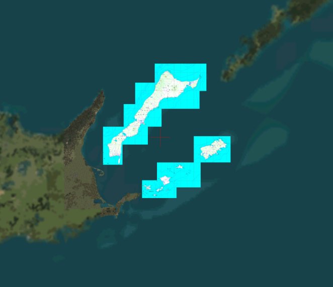
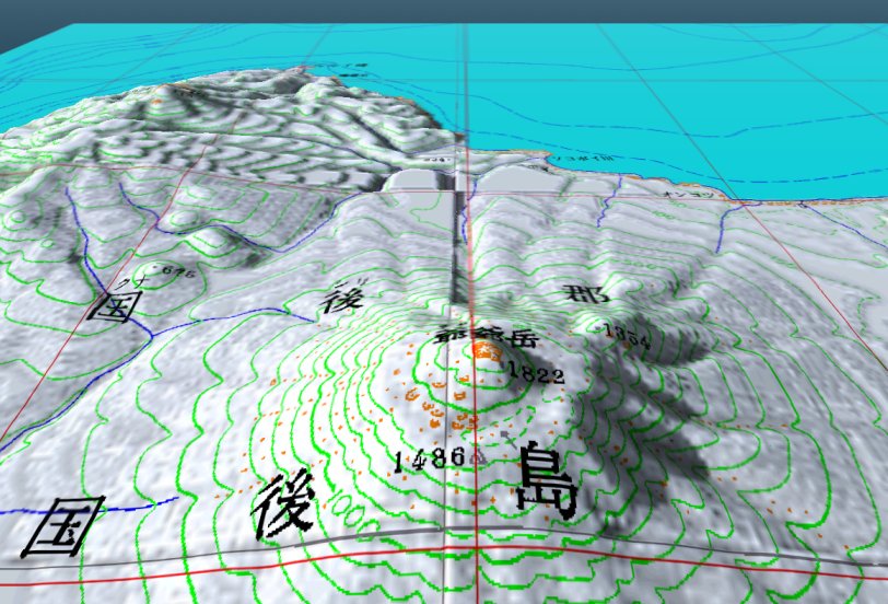
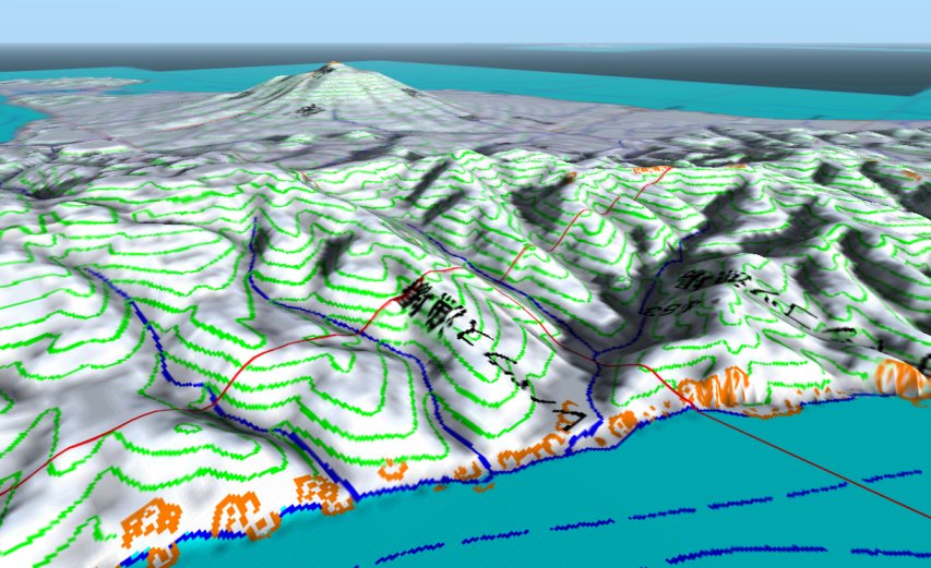
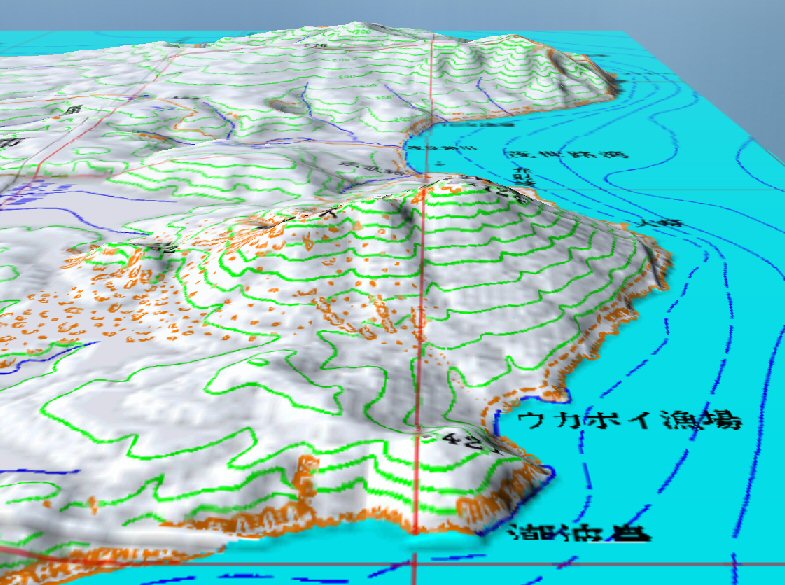
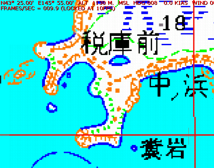
About #3, there are still error in spite of adjusting completely at a time of making scenery. Because there are tool error, difference between map plane and globe spherical surface, and error included a map itself. In this scenery, the object of it is confirming the position, the error is clearly displayed. Lat/Lon coordinate lines of WGS-84 are displayed by red lines, so you can get error condition at any point very easily. Concrete value of position error is about 100 m. This is 5 dots because original map has an accuracy of 20 m / pixel. It is your choise to use after adjusting error or use position of this scenery directly. But if you want to get vast area data, the latter option is real, I think.

About real scenery, first I start to make at Northern Territories of Japan. About all of Japan, CD-ROM will be distributed from Atatan because of much data quantity. At first, Hokkaido is released already.


Click for Nemuro, Japan Forecast


Northern Territories map scenery ver 1.0new MMFS2002 ready FS2004 ready

Kunashiri, Etorofu, Habomai, and Shikotan islands scenery is released.

Whole view of Kunashiri, Habomai, and Shikotan islands.
By displaying vicinity sea area, the character written in an original map is not lost.
Whole view of Kunashiri, Habomai, and Shikotan islands

Mt. Chacha at Kunashiri island. In this photo,
Japanese Northern Territories Terrain Scenery Detail Version is used.
Mt. Chacha at Kunashiri island

The rivers at a northern part of Kunashiri island. Like this photo,
it is nice co-operation to be seen this map scenery and Terrain scenery.
rivers

Mountains and coastline at near north edge of Etorofu island.
ì‚Ì—lŽq

Magnified real position error from Lat/Lon coordinates. Location is Suisho island.
Thin red cross at the right down side is present position. The location of it is
differ 1 dot south, and 5 dots west from the Lat/Lon coordinates.
Like this, error estimation is very clear.
error estimation


This scenery gets an approval from GSI for release.
(Approval number : Hei 15 Sou-Shi #260 )


Download
This scenery is FREE ware, but it is very appreciate if you give me a donation using this page.
Whether you give a donation or not, the function of this scenery is not affected. There is no limit to the function of this scenery.
And donation not for my scenery software but for my web site is also appreciated very much.


Jump to ----> MainPage/ Vacuum tube and Electronic DIY/ FlightSim

©2003-2004 S.Ito. All rights reserved.