
Strange way for enjoying Flight Simulator
Needless to say, Flight simulator is a software for enjoying flight, but I introduce you a strange? way for enjoying this without take off nor landing.
"3D CG"
Nowadays, 3D computer graphics is popular. We are able to be seen musical program for children on TV using 3D CG from much term ago. By improvement of personal computer recently, we can make our own 3D CG easily now. (but the software of this kind is expensive!) Most of these softwares set some region - 3D drawing paper - like the case of 2D CG, draw 3D pictures in the region, and move them with time. These can make movies, paintings, and animations using 3D in the computer. We enjoy products like a movie which has AVI, MPEG, or MOV formats.
"VRML"
VRML is also becoming common. There is not only VRML but also a division of walk-through software. In these softwares, it does not only produce movie but also walks through in a virtual world after setting some region - 3D drawing paper -, so it's a virtual reality. Most of 3D CG softwares belong to both divisions, because they make a movie by setting a path for walking through after making virtual 3D world. The concept is different from above mentiond 3D CG, in a meaning that they produce virtual world itself.
"Mountain scenery viewer software"
There is another type of software, it's a mountain scenery viewer. It can simulate a real landscape which is seen from a real mountains.
This type software makes - real world - in a computer not in a 3D drawing paper. Good software produces and displays a landscape from a position where is pointed out in a real map. But a function is restricted that the position in a map is limited only a few places, and a speed of producing the landscape is very low about one minite for making only one static picture, in spite of producing 360 degree panoramic scene. It looks like a software for re-generating good feeling at the summit after climbing a mountain with hard work.
"Microsoft Flight Simulator"
This is a Microsoft Flight Simulator, it has a Slew mode, in this mode we can enjoy beautiful sight without operating aircraft.
This is natural for FS user, but it is great, I think. Comparing to above mentioned softwares, it generates
real world like a mountain scenery viewer software. Further, it is able to go to
everywhere on the glove within the troposphere in a moment with correct positioning by specifying a position for xyz axises; latitude, longitude, and altitude. Furthere, this software simulates weather and time changing, and it is possible to specify year, month, day in a time domain. It seems mostly
"dokodemo-door" (magic door which enables to go to everywhere in the world.) of Japanese animation "Dora-e-mon". After all, this is
"a vehicle for travelling time and space". And we can see real time picture with moving, because it takes not a long time for generating scenery (it depends on a frame rate.). Further, we can see not only static scene but also moving animated scene with a dynamic scenery or like a
Moving Yananote-line scenery,
Fireworks in the world scenery, and
Nagano Olympic Ski Jumping team GOLD medal scenery; I made them. These points are evident advantages from above mountain viewer software.
The concept of a feature of this software is really great like mentioned above, but there is some limit in real. First, ability of expression is worse than above mentioned 3D CG softwares. But it's understandable for they stand only on a limited drawing paper but FS treats whole world. And it seems that FS is high cost / performance software which has such a great concept, it costs around 10,000 yen. Worst thing of FS is a problem of displaying scenery. That is; there is a limit of a number of objects able to be seen in the same time, and further there is a hysteresis effect. If there is only a limit of numbers, it is avoidable by making simple objects using conditional statements. But hysteresis effect is a really problem. I write detail situation about it
here, and read it please.
"Know-how for operating a vehicle for travelling time and space"
For operating Microsoft Flight Simulator "a vehicle for travelling time and space" (it's easy only set Slew mode.), it is an important point how to decrease hysteresis effect. In usual "flight", we take off from an airport - fly horizontally - landing to an airport; unfortunately, this type of moving is most affected by hysteresis effect.
For decreasing hysteresis effect, it is effective not flying to horizontal direction. That is, from very high altitude, see just under direction.(using shift key + 5 key of num keys.) And goes horizontally to a destination with seeing under. After reaching just upper the destination, then goes down altitude, change to horizontal sight, and enjoy sightseeing. Most scenery of not easy to see in a usual flight is affordable to enjoy by this method. (including MEX way scenery)
"More strange way for enjoying FS"
If sightseeing using above mentioned way is strange, making such a thing is more strange. "What is fun in a making only a highway ?" I sometimes think this question, but it is a great mystery !! I introduce a situation of road work at
Making of Tokyo Highway, see it please. Thanks for reading.
Link
The sentences before here are written between 1997-1999.
Mar. 27, 2005 attached
World Wind
The great NASA releases a software
World Wind for a download service as a Freeware.
This software works as before mentioned
"a vehicle for travelling time and space" in space axis. Pros and cons to the MSFS in articles are following. The first, good points are;
- Because this is not a flight simulator, we need not working for treating a plane, we can go to the world only by a mouse moving.
- Completely free software this is. Further, map data are downlowded from the net, therefore we do not need install huge data to our local HDD.
- We can see predetermined resolution image everywhere in the world.
- Completely "real photo scenery" this is, and there is no problem of position error like in the MSFS from the first.
- There is enough resolution image for distinguish one car in the part of the USA.
- Working lightly comparing to MSFS. A joystick is not needed.
bad points are;
- There is no representation about a season, year-month-date, and weather. But there is low resolution image of the night.
- There is no 3D object which is the heart of FS scenery. A detail of the buildings is not able to be represented.
- The resolution is lower than maximum resolution of MSFS. But there are altitude data from the first, so this is working like as a TerrainMesh scenery. There is no animated object (maybe).
This is brief article of it, I think. But for the people who does not want to controlling the plane, this is the software which has
possibility to overturn the reason for existence of MSFS. From the point of view to involve the other many people who is not a fan of flight simulator, there is possibility to grow to the big business ? in the future; this is not a time to make a scenery as a hobby by only a one person.... maybe, I think. This is the software for recognizing the power of the USA again to the world, like GPS satellites are utilized freely in the world. We need to watch the next development of this, I think.
Please watch some examples with photo.
First, the example of high resolution.
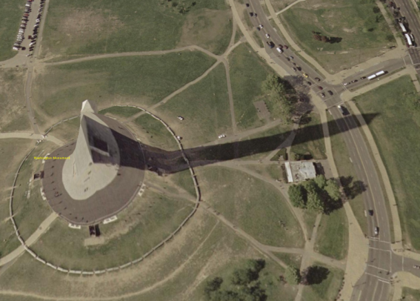
This is the Washington Monument. Because of seeing from slanting, the altitude representation is not correct. This is because there is not 3D object data but only TerrainMesh data. But this is great high resolution, we can distinguish one car.
The south of the White House.
Great high resolution too. We can see one car respectively.
The White House.
Because there is no 3D object, we cannot see the building. But this is high resolution image.
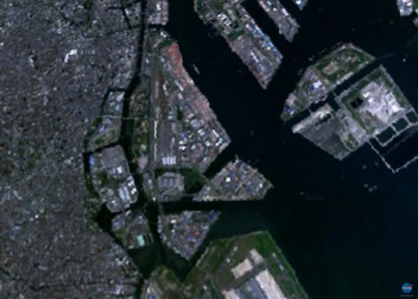
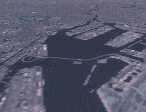
Neighborhood of Oi-wharf and Keihin-jima in Tokyo, Japan.
The resolution is lower like this. But the position and scale are exact.
Rainbow Bridge
Low resolution and no bridge object. Only see this photo, this is very poor, but I feel including future possibility in it.
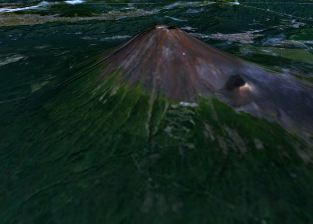
Mt. Fuji
The distant view is not so bad. I feel it is good match for MSFS scenery in the area where is only TerrainMesh scenery data.
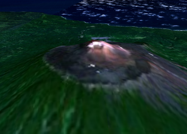
Mt. Chacha at Kunashiri island
Very rural area like this, this is nicer than MSFS maybe. (But there is difference in level of altitude NASA data...) We can see the difference between grassland bevel of Mt. Chacha and no grass area. Please watch the map scenery
HERE too.
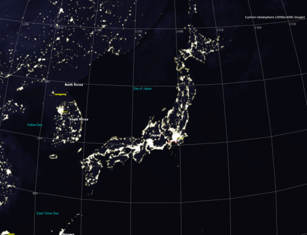
The night of Japan
Only this image is good, but we cannot enlarge because of low resolution. It's very poor. It is not enough yet.
Rainbow Bridge #2
I change the satellite. The color is worse than before one, but resolution is better a little. Like this, there has a possibility in the future depending on the photo resolution of the satellite, I think.
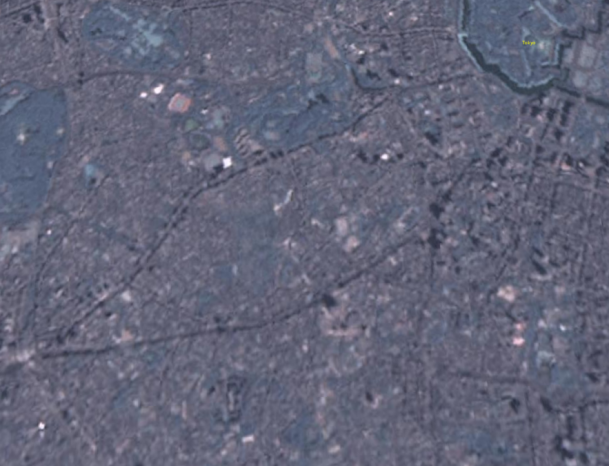
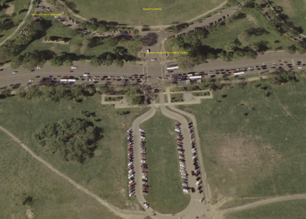
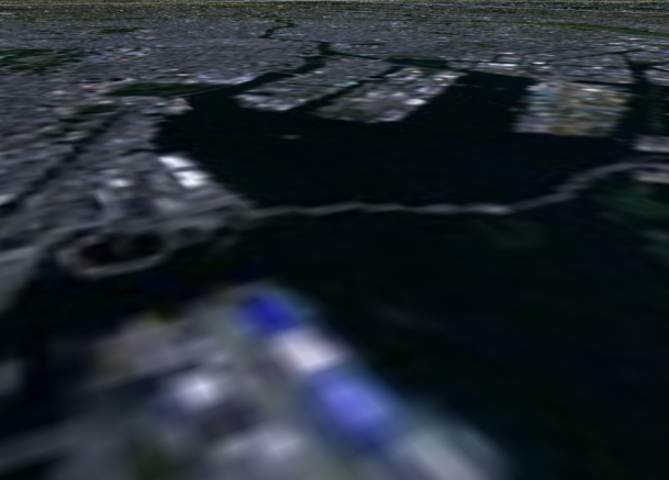
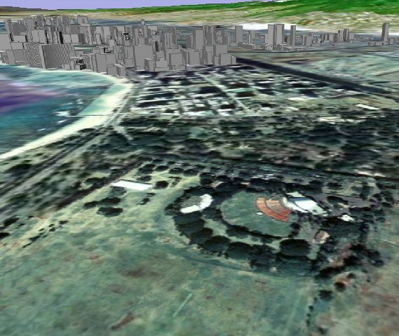
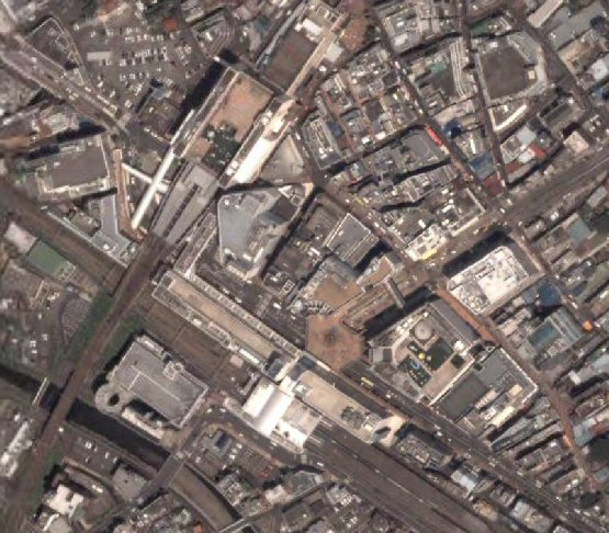
From Shibuya to imperial palace
The lower center is Roppongi Hills, and its right down is Azabu-juban and Ichi-no-hashi. Black line is Tokyo MEX way #3. The left edge is Shibuya station, and upper right edge is the imperial palace. Little upper from center black line is route 246.
There are Yoyogi-park and Shinjuku-gyoen park at upper-left.
Jul. 1, 2005 attached
Google Earth
It seems that this is the second brew of above World Wind, but this is interesting as it is.
Google Earth, this is also available for a download service as a Freeware. Pros and cons to the World Wind in articles are following. The first, good points are;
- There is a detail photo of NYC. (no detail photos are there in World Wind.)
- In a metropolis, it is good to see well, because there are 3D objects of buildings at a part of the USA cities.
- High resolution are kept in Tokyo vicinity area, and we can distinguish house by house.
bad points are;
- There is Terrain data, but I feel the mesh is not so detail.
- In some places, a description of the land name and a real place are different.
- Speaking about only in Japan, this is high resolution photo in a big city, but low resolution in rural areas. Further, there are not enough land names in rulal areas, so it seems that World Wind gives more fun in a rural area.
This is a first impression. But, privately, I feel it is a best point of this software
to be able to watch detail Tokyo scene in old-time. Let's enjoy with photos in the next.
First, in NYC.
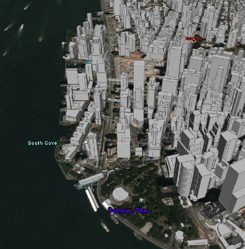
Battery Park and Ground Zero. 3D buildings give good mood (but no textures). This is the scnece which is not able to be supported in World Wind.
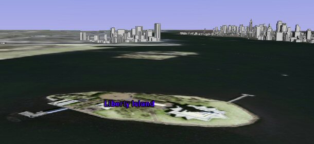
Statue of Liberty
But there is no 3D Statue object. We can have fun only to see buildings in Manhattan.
Honolulu view from Kapiolani park
Going to Hawaii, this is east waikiki in Oahu island. Like this, there are only buildings in the west part of waikiki. So we cannot enjoy tilt photo at east of waikiki.
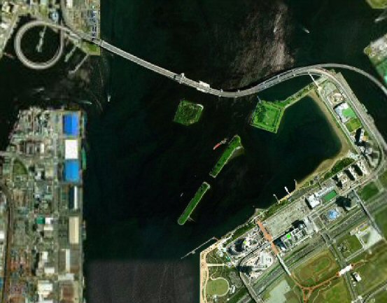
Here is in Japan, Tokyo, Rainbow bridge and Odaiba area.
Oh nice ! high resolution is kept even outside of the USA !
In personally, I like Google Earth from this photo.
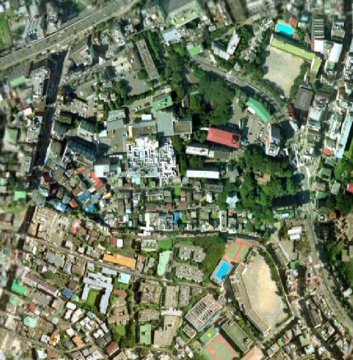
Roppongi 6-chome before re-development.
This is really great. Because photo is old,
There is no Roppongi Hills yet. We can watch the scene before re-development in high resolution, really house by house ! This photo is very rare because this photo gives us a lost scene now with detailed expression.
We can distinguish old "Yabu-shita dori st." (Beginners call this street as Genseki-zaka dori, it is incorrect !!!) very clearly.
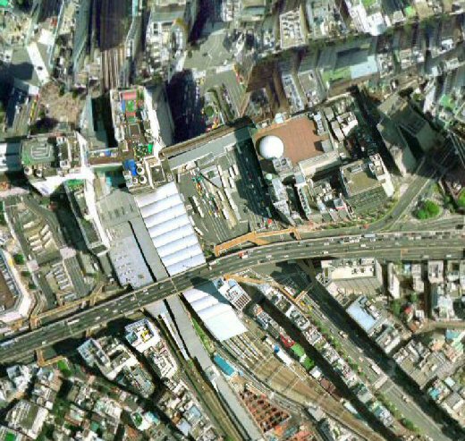
Shibuya station
There is Tokyu-bunka kaikan building and sphere dome of Goto planetarium. This photo is very rare like a time trip.
Machida station
Going local speaking, Machida station of JR and Odakyu lines. High resolution is kept at near outside of entrance of the station of Yokohama line even distinguish car by car. It is amazing to see this high resolution even in rural Machida.
Lower left is Yodobashi-camera maybe.
Granberry Mall
Minami-Machida station, Granberry Mall, and Carrefoure. Right edge is a cross point of Route 246 and Route 16. Left edge is Tsuruma park. We can see it with same high resolution as the center of Tokyo.
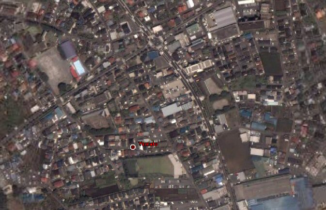
Land name "Yamato"
Not easy to see, the place which is marked as "Yamato" at the center bottom; in real, here is not Yamato but Tsuruma in Machida-city. Like this, land name are not correct. The upper center is Machiya-hara crossing of Machida-kaido st.
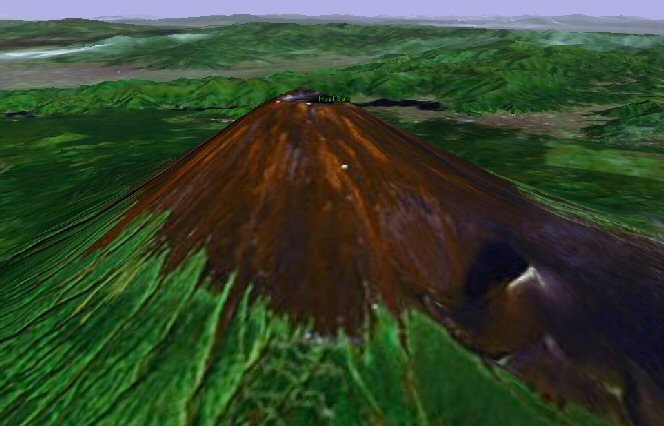
Mt. Fuji
The last is Mt. Fuji. Land name is amazing "Huzi san". "Huzi san..." likes person's name of TV drama in a daytime.
It seems that Terrain Mesh resolution is lower than World Wind. Therefore, Google Earth is an entertainment software for Tokyo and vicinity ??
Jan. 16, 2007 attached
Virtual Earth 3D
Long time has passed. At last, Microsoft releases not FS but 3D map. In Google Earth etc, there is only a few 3D objects, but there are 3D objects with texture in the Virtual Earth 3D. But, on the first time, we hear that Virtual Earth 3D has not been able to be used in Windows Japanese version with clash. Now we hear the news the bug is fixed.
This is a news by impress in Japanese. FYI
Back to Flight Simulator Scenery page.
©1997-1999, 2005, 2007 S.Ito. All rights reserved.